Scenic Map Western USA Price Snapshot
Scenic Map Western USA by GrangerFX is priced at $4.99 on the Apple App Store, with no in-app purchases. It holds a 4.3★ rating from 12 reviews.
Listing last updated: 2024-01-19. Source: public Apple App Store data, compiled via the App Pricing Lab methodology.
4.3★
12 reviews
2010-04-01
Released
2024-01-19
Last Updated
Rankings
| Category | Collection | Rank | Date |
|---|---|---|---|
| NAVIGATION | top-paid-ipad | #41 | 2026-03-12 |
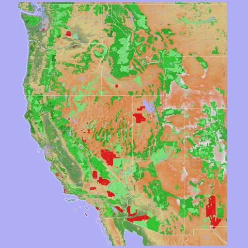
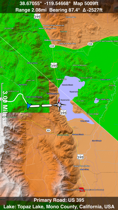
Screenshots


About Scenic Map Western USA
A 3D topo map of the Western USA and Hawaii. The vector map data is contained within the app and can be used without an internet connection. Use it in a car, a boat, a plane or while hiking. It is like having more than a third of the country in your pocket.
Scenic Map now covers the entire world via online maps. The maps are cached automatically so they can still be used when there is no cell coverage. Turn on Online Map in the Settings menu and you can then scroll or go to any location on the planet. Satellite image overlays add breathtaking detail and realism to the maps (tap preset 2 or 4 when Online Map is enabled). You can use them as you travel to see what is hidden from view at ground level. This takes moving maps to a whole new level.
Use the two finger vertical swipe gesture to tilt the map for a 3D view. Scroll like a map or fly like a flight simulator. Enable Joystick Gestures in the Settings menu and then fly around the terrain using a virtual joystick. Prefer only 2D maps? Enable the 2D Map option in the Settings menu.
Scenic Map is simply the best 3D topo map available for a mobile device. You will see incredible detail while scrolling, rotating and zooming perfectly smoothly. You will see every road even if you zoom out to the altitude of a satellite. As you zoom in, you will see every small bump and hollow of the Earth and terrain features as small as ten meters. Unlike old fashioned topo maps, Scenic Map’s roads and trails are up to date thanks to OpenStreetMap.org. It contains polygons for urban areas, shopping malls, an ever growing number of buildings and many other features, The best lake, pond, stream and rivers from the USGS and Canadian public databases are also included.
Tap the GPS center button to begin tracking your location. As you move, you will generate a track file. Tracks can be replayed with video like controls to speed up, slow down, pause, restart or skip to the end. You can display existing tracks while recording another if you want to retrace your route. When online, you can automatically create a route from your current GPS location to any other point on the map. Tracks can be received from or sent to other apps in GPX format. GPS recording stops automatically after you have remained stationary for some time or you can choose to manually stop tracking by tapping on the top track in the Tracks view.
Never before have maps been this customizable. For example, you can turn on or off the roads. You can change the lighting direction or remove terrain shading entirely. You can display contour lines even over satellite images. There are five presets which let you quickly switch between map styles. Use Metric, English or Nautical units and choose one of four different coordinate displays including UTM.
Want to learn more about a map feature? Tap the target icon and center the feature under the compass rose to display its name, type, urban area, county, state, elevation and coordinates. You will also see a bear
Frequently Asked Questions
Is Scenic Map Western USA free?
No, Scenic Map Western USA costs $4.99.
What is the rating of Scenic Map Western USA?
Scenic Map Western USA has a 4.3 out of 5 star rating based on 12 reviews on the Apple App Store.
Who made Scenic Map Western USA?
Scenic Map Western USA was developed by GrangerFX. Visit their website at http://scenicmap.blogspot.com/.
Developer
Explore More
Related Navigation Apps
Share & Embed
Use these badges on your website or blog to link back to this app's data.
Rating Badge
<a href="https://apppricinglab.com/app/apple/363746157"><img src="https://apppricinglab.com/api/badge/rating?store=apple&app=363746157" alt="Scenic Map Western USA rating on App Pricing Lab" /></a>Rank Badge
<a href="https://apppricinglab.com/app/apple/363746157"><img src="https://apppricinglab.com/api/badge/rank?store=apple&app=363746157" alt="Scenic Map Western USA ranking on App Pricing Lab" /></a>